
When I was growing up in La Jolla, a regular fun adventure was to ride my bike up the hills and north to the Torrey Pines State Park. It was quite a ride; the hills seemed steep, but in the end it was worth the effort.
Of course the Torrey Pine was also quite an important tree to us locals: they only grew in this one little area. Back when I was a kid, I also remember being taught that they also grew on an island in Japan. I just checked THIS website, apparently my memory is faulty or the botanists have rethought that thought!

We were told that the Native people in the area used to gather the Torrey pine needles and weave baskets with them. Of course we kids tried our hands at such basket weaving too...but with little success.

We used to scamper around the park, enjoying the pine and sage and sea air mixture, especially after a rainstorm (a rare occurrence) or on a foggy day (which happens pretty much every day along the coastline.)

The fact that the Torrey Pine tree was uniquely identified by having five needles in each bundle was drilled into our heads at school or during nature talks at the park.

I made sure Laura and Bernie checked that fact out, and that we photographed the detail for blogging purposes. After reading the link's website, I now know that detail really wasn't all that uncommon among pine trees!

Still...it is a lovely tree.

Growing up a palm tree was a far more common neighborhood tree; it was a special treat to walk in the deep pine needle covered areas.

(Laura happened to be nearby when I was considering the pine needles; I think I am more impressed by her red hair than I am by fallen pine needles which are oh so common in our SLC location.)

The main reason I wanted to go to TPSP was to once again walk the most memorable trail from my childhood, the trail that wound through a high sandstone slot canyon aptly named "Fat Man's Misery" due to the winding narrow passages.
We kids would walk the trail down to where it would seriously narrow, then puff out our tummies and declare that we had gotten stuck.
Sometimes we made fearful speculation about whether we would be too big to slip through the passages in a year or two. Such innocent hijinks went on, yet I also vividly recalled wishing I had had a camera to snap pictures of the beautiful passageway that eventually lead to the ocean's shoreline below the cliffs.
I checked the map to refresh my memory as to where the Fat Man's Misery trail head would be found.
It wasn't listed!
Vaguely I remembered something from back in the early 70's that it had been renamed something more sensitive to the larger people of the world.
There were only two converging paths that lead to the ocean shown on the map; we headed out to one of the trail heads, figuring one way or the other Fat Man's Misery would be found along the way.

The foot path of my childhood had been reworked to a well marked trail through the chaparral.
The weather eroded red cliffs were more visible than I had remembered them.

You can imagine how striking this scene is with fog, or during a blazing orange sunset.

Looking south it is possible to just make out Scripps Pier, just blocks from my family home, and the blocky high rise on the far point that rises above La Jolla Cove.
The cliffs provide a natural updraft that is regularly enjoyed now by hang gliders; back in my childhood it was more likely to be a real glider that had been launched from the old glider field left over from when the grounds were used as a WWI military training grounds.
The cliffs provide a natural updraft that is regularly enjoyed now by hang gliders; back in my childhood it was more likely to be a real glider that had been launched from the old glider field left over from when the grounds were used as a WWI military training grounds.

May I just say the easy hiking trail alone provided plenty of picturesque views?

This was the Saturday after Thanksgiving; people were out visiting family and large groups of people were taking in the views.

In Utah we call this sort of erosion "Hoodoos".
San Diego only gets a few inches of rain each year; these forms are both water and wind created sculptures.

What little water falls carves canyons easily.
This was only about six inches deep, but I could image that given a few hundred years it could amount to quite a canyon!
This was only about six inches deep, but I could image that given a few hundred years it could amount to quite a canyon!

I kept looking for side trails that might lead to Fat Man's. This looked like a possibility...

I still don't understand how holes like these are created, but they sure were fun to play in as a kid.


From here we could see porpoises playing in the water, and if you look in the upper right corner, you can see a flight of pelicans winging along.

Don't you just love the bands of color?

More Southern California confusion: several kinds of cactus, including barrel cactus grow in the area just a stone throw from the beach.
So we are at the seashore in a desert pine forest, right?

Then we made it to the beach.

The fall and winter tides are quite high and low; we just lucked out an arrived while there was still beach to walk on.

Now the real fun begins: taking a zillion pictures!


(Sometimes I even take pictures of my family members if they happen to be standing nearby...)

I could happily document every colorful inch of the cliff front walls.


(Need a naturalist to explain this finger sized hole near the base of the cliff.)

Now obviously for there to have been layers of seashells covered, at one point this had to be flat and under water. How did the rest of the layers arrive?

And why are the layers of various colors?

Gawking at the cliff walls; remember to stay aware that parts can break off at any moment.

Now can you understand why I longed for a camera while I was here as a kid?
(It would have been frustrating to only be able to take 12 or 24 shots though. And then to have had to wait a week for the film to come back...)

To get down and around the cliffs it is necessary to walk along this very narrow walkway worn into the side of the cliffs.

Below the path: Bathtub Rock. Bernie used to spearfish off this rock before he met me. The ranger's family attended the church he attended, there were three sons who lived in the old ranger station in the park full time. It is funny to think those teen age boys are now in their late 40's. I hope they realized what a delightful childhood they had growing up in a State Park!

Yes, it was cold enough that wearing a sock cap and jacket made sense.

(stare...gawk...touch...look up...step back...)

The hang glider may or may not have as good of a view as I have...

Actually, if you look away, she becomes a mermaid and in a flash dives beneath the sea.
Prince Eric...calling Prince Eric....
(We can dream.)

My surfer, back in his natural habitat.

(wait for it...wait for it...now! Click! Got it! Got the shot!)

Someday I'd like to try this. Maybe.


Laura cracked us up with a story about one of her more witless friends: She mentioned Bathtub Rock to a friend...her friend asked Laura how she got a bath tub over the cliff to place out in the ocean on a rock.
Her friend was thinking of a claw foot bathtub, and believe me, she was serious.
It would make for a very fine prank...but no...the tub, for now, is just a natural indentation in the rock, perfect for wallowing in on a warm summer day.
Her friend was thinking of a claw foot bathtub, and believe me, she was serious.
It would make for a very fine prank...but no...the tub, for now, is just a natural indentation in the rock, perfect for wallowing in on a warm summer day.

I suppose at mid-tide one could safely snorkel around the rock. Maybe it is even fully revealed at low tide?

It certainly would not be safe to swim around today. Look out for crashing waves!

The blocky high rise in the distance: the monumental, 17-story, "939 Coast" condominium dominates the view. Totally out of proportion to the rest of the neighborhood, the building started a huge fight between those who wanted La Jolla to retain its low-rise, low-density character, and those who wanted to replace the existing buildings with imposing high-rises. The uproar over the construction of this building in 1965 triggered a 50-foot height limitation on new construction.
I can remember how the coastline looked before and after, being 11 years old at the time of the construction. I went to school with the daughter of the man who pushed through the construction of the building; he was considered a traitor to the community and she probably knew it too.
Sigh. It still aggravates us natives.

Bernie took the camera at one point and got a picture wind blown me.

The small trail kind of peters off and it takes a bit of fancy foot work to finish the walk down.

Bernie's girls.

It is almost odd to not see Laura here without a surf board under her arm.

For fun: fiddled around with the settings for this picture. Don't know exactly what I did to make it look like this...

Yup, the cliff side is still holding. Just checking.

Looking north up the coast. If we walked south for about a mile the people on the beach would have been naked.
Seriously.
Black's Beach, everyone goes...you don't need no buttons or bows.
Black's Beach, everyone knows: there's a bunch of crazy people there without any clothes!

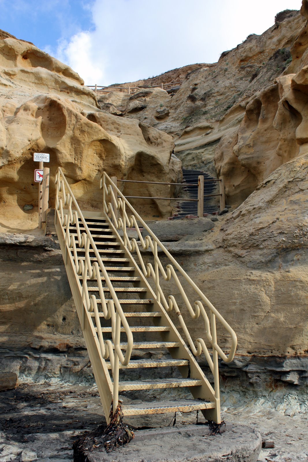
The walk back up the cliff was via this stairway. Was it here when I was a kid?
I don't remember. It could of been.

This was the huff-and-puff part of the climb back up.

We actually are walking back on a different path now. The trail we took earlier can been seen between the two hoodoo mounts.
Tomorrow: The rest of the park, and the mysterious disappearance of Fat Man's Misery will be explained!
Tomorrow: The rest of the park, and the mysterious disappearance of Fat Man's Misery will be explained!